2 Fishes Designs
![]() Summer on Skye
Summer on Skye

The Summer on Skye series of counted cross stitch embroidery designs aims to capture the island in its most beautiful season.
Each design in the series is 42x42 stitches, approx 7.5cm square (3") when worked on blockweave 14 blocks per 2.5cm (1"). The individual designs are grouped in themed sets of 3 charts.
Difficulty: These designs are quite complicated to stitch. They are not large projects, however, and have been successfully tackled by beginners, although some experience would be an advantage. As well as straightforward cross stitch, there are also fractional stitches, blended threads and back stitch. Instructions are provided for these stitches.
This is a 3 chart set consisting of:

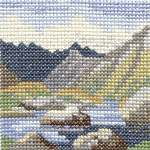
I sketched this view of Loch Cill Chriosd (a couple of miles from Broadford on the road to Elgol) late one August afternoon. The colours glowed like jewels against the rather sombre backdrop of Blaven, the distant mountain.

Blaven is one of the most striking mountains in Scotland, and in June its lower slopes are a lush green above the calm waters of Loch Slapin, where yellow flag irises grow in abundance.

The road to Elgol ends at the car park by the jetty. From here (if visibility is good!) you can look out across Loch Scavaig to the Cuillin Hills. The jetty was rebuilt recently and the township has a small but thriving fishing industry. The mountain which forms most of the backdrop to this scene is Gars-bheinn.
This is a 3 chart set consisting of:

With its companion "Am Basteir", Sgurr nan Gillean is one of the best-known peaks on Skye.
This loch has been called "The jewel at the heart of the Cuillin", seen here in its setting of dramatic mountains.

The view of the Cuillin from Elgol Beach is recognised as one of the most beautiful on Skye, especially with the evening light as a backdrop to the mountains.
This is a 3 chart set consisting of:

Ord is on the North West coast of Sleat. In clear weather it is well worth the detour for the spectacular views of Blaven and the more distant Cuillin Ridge. This picture shows Blaven in the distance, separated from Ord by Loch Eishort.

Also known as Eilean Iarmain, this ebb-tide island with its lighthouse is accessible on foot only at low tide. It lies in a sheltered bay on the south-east shore of Sleat, and the distant hills are actually on the mainland.

Armadale Bay may be the visitor's first encounter with Skye, as it is the site of the pier, and terminal for the ferry from Mallaig. In summer the bay teems with boats, from yachts to fishing boats, dinghies to cruisers.
This is a 3 chart set consisting of:

Macleod's Tables are a pair of basalt plateaux about 500 metres high. Here they form a dramatic silhouette against the sunset, across Loch Bracadale.
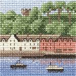
A view of the harbour and bay backed by the wooded hill known as "the Lump", and the old look-out tower.

A famous Trotternish landmark overlooking Loch Fada and the sea.
See Also: 2 Fishes Designs homepage | Skye Classics | Celtic Saints | Lindisfarne Collection | Samplers | Bookmarks
Copyright © 1998-2014 Eliza Wright, Isle of Skye